Disaster Imaging Inc
Observe. Innovate. Understand.
Pioneering the integration of UAS, satellite, radar, modeling and AI to transform how we understand and respond to tornadoes
Our Mission
Our mission is to reveal how tornadoes behave and cause damage by integrating cutting-edge observations with advanced modeling and AI— strengthening both science and community resilience.
DII collects comprehensive observations of tornadoes and their impacts using Uncrewed Aircraft Systems (UAS), satellites, ground-based cameras, and field measurements. By integrating these data with model simulations and artificial intelligence, we examine new insights into tornado behavior and the damage they produce.
We bridge the gap between innovative research and real-world impact – advancing fundamental science while serving communities, especially in rural areas that traditionally have not been a research focus.
How DII Transforms Tornado Research
Disaster Imaging Inc (DII) uniquely combines expertise from several scientific specialties to advance our understanding of tornadoes and the damage they produce…
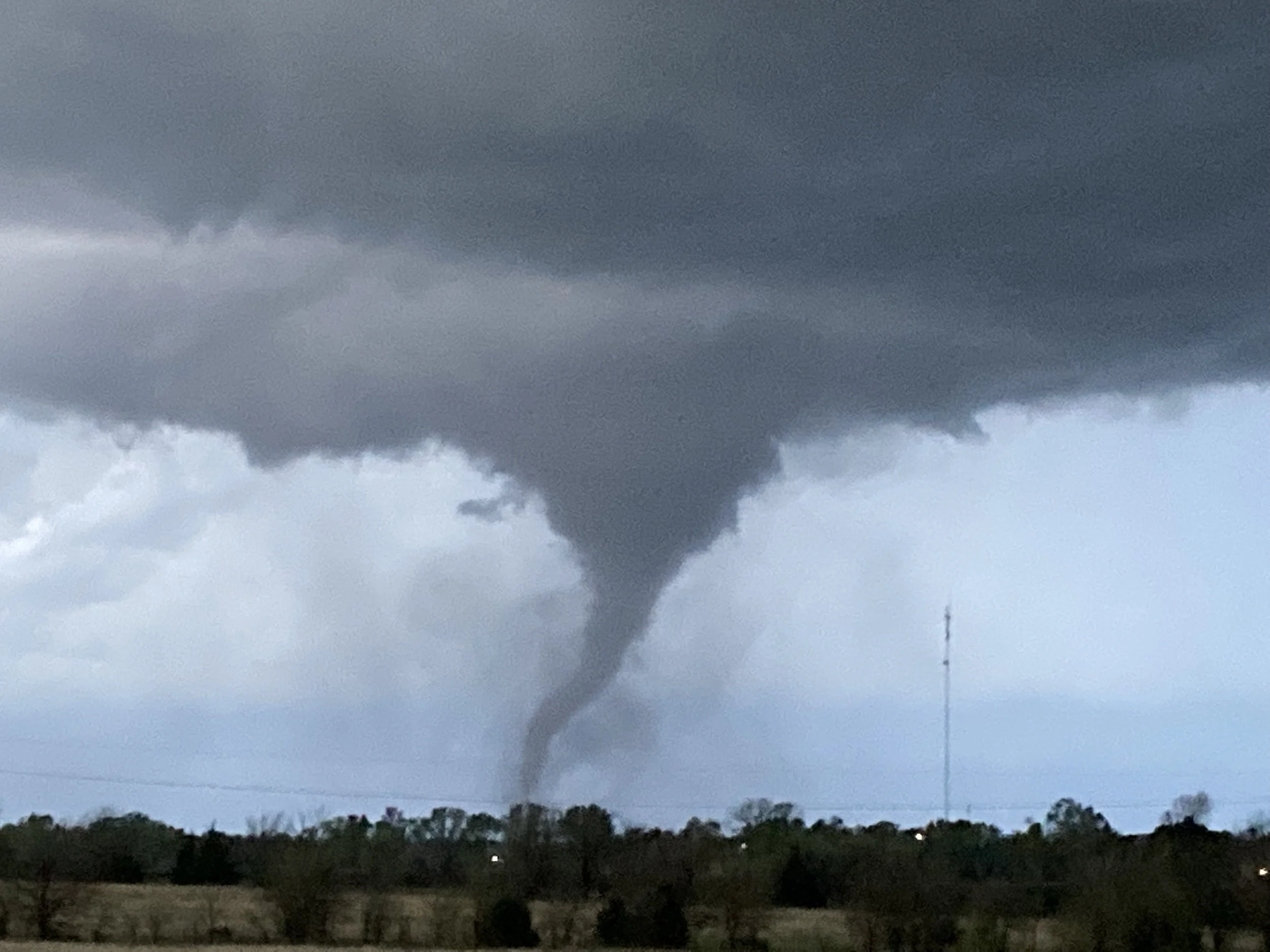
Quick Response Observations
Years of experience have taught us how to pre-position assets, adapt to the disaster and the field conditions, and obtain unprecedented data sets. DII collects observations of tornadoes and their impacts using Uncrewed Aircraft Systems (UAS), satellites, ground cameras and in-situ observations. We use AI to quickly assess the nature and severity of the event.
Computer modeling
We will perform innovative modeling to understand the winds, damage, and debris at the ground where lives are impacted. Our high-resolution simulations reveal tornado behavior at scales never before possible – from the vortex structure to individual debris trajectories.
Artificial Intelligence
We are developing unique tools to understand and predict tornado damage patterns, intensity, and impacts by combining theory, modeling, and high-resolution damage imagery and analyses. Our machine learning approaches extract patterns from massive datasets that would be impossible to identify manually.
Innovative Tornado Observations
Building upon 40 years of leadership in tornado observing campaigns, DII will be fielding innovative systems to observe the near-ground winds and debris in tornadoes. Led by Erik N. Rasmussen, Ph.D. – an architect of VORTEX, VORTEX2, VORTEX-SE, and PERiLS – we bring unmatched field operations expertise to breakthrough research.
Sharing Information
We share our findings with the NOAA National Weather Service, emergency managers, researchers, and communities to improve preparedness, response, and resilience. Our proven Research-to-Operations (R2O) workflows ensure that scientific discoveries translate into operational impact.
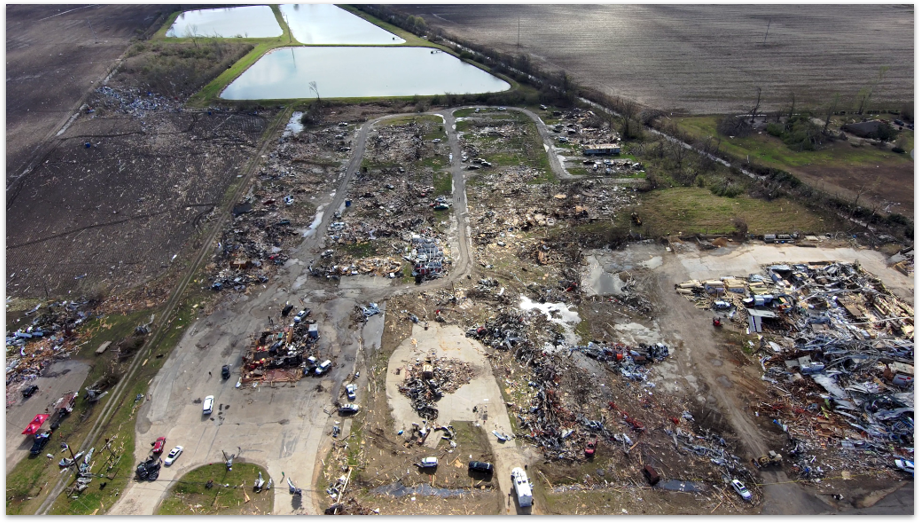
Our Impact – Discoveries That Are Changing Tornado Science
48+ Damage Assessments. 70+ Peer-Reviewed Publications. Breakthrough Insights.
Through our integrated approach, we’ve made discoveries that are transforming how the scientific community understands tornadoes:
Understand how land cover transitions affect tornado intensity – advancing fundamental understanding of tornado-environment interactions
Understand terrain effects on tornado evolution – showing how topography can influence tornado behavior and intensity
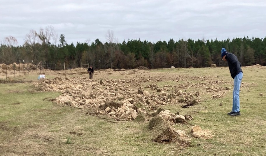
Document and Investigate cycloidal marks – providing insights in sub-vortex structure invisible to traditional survey methods
Document damage patterns at 3cm resolution – 100x better than satellite imagery, capturing unprecedented detail
Innovative integration of UAS + satellite + radar data – creating multi-scale understanding from sub-meter to regional scale
Advance data-sharing workflows with NWS – bridging research and operational response
Our work has been recognized with a NOAA Bronze Medal nomination and published in the field’s top journals including BAMS, Monthly Weather Review, and Natural Hazards Review.
Who We Serve: Research Partnerships that Advance Science and Operations
Research Institutions
Universities, national laboratories, and atmospheric science programs seeking unique datasets, collaborative field campaigns, and co-authorship opportunities on high-impact publications
Government Agencies
NOAA, NSF, FEMA, and federal program managers funding innovative research with proven operational impact and measurable community benefit
National Weather Service
Weather Forecast Offices and Warning Coordination Meteorologists needing rapid damage assessment, EF-scale rating support, and access to remote or impassable areas
Emergency Management
State and county emergency managers requiring rapid situational awareness, high-resolution documentation to assist disaster response and recovery
Support Our Mission
Support Breakthrough Tornado Research
Help Us Advance the Science that Saves Lives
Disaster Imaging Inc is a women-owned 501(c)(3) non-profit scientific organization pioneering the use of UAS, satellite, radar, computer models, and AI to understand tornado behavior and impacts.
Why your support matters…
Every tornado that strikes reveals new questions about how these powerful storms behave. With your support, we can:
- Deploy rapid-response UAS teams to capture critical data before cleanup begins
- Conduct innovative research that advances fundamental understanding of tornado dynamics, behavior and impacts
- Develop AI tools that characterize and predict damage patterns
- Share data with the NWS and emergency managers to improve response and recovery
- Focus on rural areas often overlooked in past research
- Train the next generation of tornado researchers and UAS operators
We are grateful for the support of the Jonathan Merage Foundation and anonymous donors!
We are grateful to the many people we have encountered in tornado-damaged areas who generously helped us do our work despite their difficult circumstances
Disaster Imaging Inc is a 501(c)(3) non-profit scientific organization. Your donation is tax-deductible to the fullest extent allowed by law. EIN: 33-1948996
News From Disaster Imaging Inc…
Dii Collects Unprecedented Data from the Enderlin, North Dakota Tornado
On the evening of 20 June 2025, an EF-5 tornado struck the area south through east of Enderlin, North Dakota. 36 hours and 915 miles later, Disaster Imaging was on the scene collecting an unprecedented tornado damage data set. This story is under construction… check back here around 10 February for…